
For each image, enter your guess in the comments and be sure to include the image’s letter. You enter multiple image guesses in each comment or do a new comment per image.
As always, you can click the image to see a larger version of it.
Good luck!!
A. From Garfield

B. From Horvath

C. From Garfield

D. From Krenek
E. From Garfield

F. From Lighthouse

G. From Garfield
(what can we say, she sent in a BUNCH of really good ones!!)

H. From Phil Ower

I. From Garfield

J. From Sasha
K. From Krenek (you thought I was going to say Garfield, didn’t you?)

L. From Phil Ower

M. From Steve Willis
M. = Huge brass sculpture of a swellfish, at the Horticultural Exposition of Jiangsu Province in east China’s Yangzhong city. Yangzhong, Zhenjiang, Jiangsu, China
M. from Steve Willis: Puffer fish Yangzhong, Zhenjiang, Jiangsu, China. Coordinates 32.197300°, 119.827785°.
B. From Horvath: Volcano Bromo, Indonesia. Coordinates -7.934732°, 112.947433°.
A. From Garfield: Dinant, Belgium. Coordinates 50.260385°, 4.911305°.
A. = Charles-de-Gaulle Bridge: pont Charles de Gaulle – Dinant, Belgium
B. = Mount Batok, Indonesia.
C. = Tenby Castle, Tenby, UK.
D. = The Tower of the New Town Hall (věž Novoměstské radnice) Prague, the Czech Republic. 50° 4’41.34″N 14°25’16.48″E
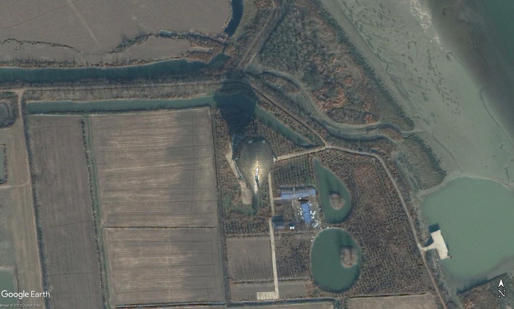
F. = Rujm el-Hiri – Gilgal Refaim, an ancient megalithic monument consisting of concentric circles of stone with a tumulus at center. It is located in the Israeli-occupied portion of the Golan Heights.
32°54’31.19″N 35°48’3.82″E
C. From Garfield: Tenby Castle, Pembrokeshire, Wales, UK. Coordinates 51.672468°, -4.694647°.
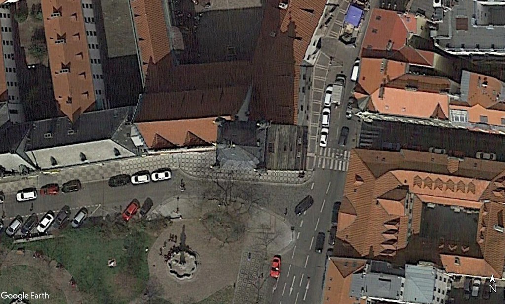
D. From Krenek: Tower New Town Hall, Prague, Czech Republic.
Coordinates 50.078141°, 14.421278°.
F. From Lighthouse: Rujm el-Hiri, Israël. Coordinates 32.908632°, 35.801156°
M. Puffer fish statue in Yangzhong, China 32,1968433 N 119,8288605 E
K. From Krenek: HEART Herning Museum of Contemporary Art, Herning, Denmark. Coordinates 56.131791°, 9.021605°.
Got one! M is the Yangzhong puffer fish on the island just off Yangzhong, China.
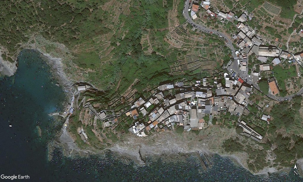
J. From Sasha: Corniglia, Italy. Coordinates 44.119821°, 9.708005°.
E. From Garfield: Seelisberg, Urnersee, Switzerland. Coordinates 46.980762°, 8.583540°.
E. = Treib – Seelisberg Cable Railway, Switzerland
46°58’55.42″N 8°35’0.06″E
Luckily (or not) I got all of them in a day’s work
A Charles de Gaulle Bridge, Dinant, Belgium
(B Hindu temple, Mount Bromo)
C Tenby Castle, UK
D New Town Hall Tower, Prague
E Selisberg, Switzerland
F Rujm el-Hiri stone circle, Golan Heights
G Mount Tuam, Canada
H Pen-y-Gwryd Hotel, Wales
I La Brea Pitch Lake, Trinidad
J Corniglia, Italy
K HEART Herning Museum Of Contemporary Art, Herning, Denmark
L Portmeirion, Wales
M Zheijiyang giant pufferfish at 32.1974621 N, 119.8278798 E
so far
B- Gunung Batok, just north of Mt Bromo, Inodnesia
C- Tenby, United Kingdom
D- New Town Hall (Novoměstská radnice) , Prague, Czech Republic
E – Just north of Seelisberg, Switzerland, 46°58’51.30″N , 8°35’1.24″E
F- Rujum Al Hiri, Israel’s Stonehenge
H- Pen Y Gwryd Hotel, North Wales.
I- La Brea Pitch Lake, Trinidad and Tobago
J- Corniglia, Italy
L- Portmeirion, North Wales
M- Pufferfish Sculpture, Zhenjang, China
Will try for A, G and K now
J. = Corniglia, one the five villages of Cinque Terre, Italy.
L. From Phil Ower: Portmerion, Wales, UK. Coordinates 52.912872°, -4.098917°.
H. From Phil Ower: Pen-y-Gwryd, Wales, UK. Coordinates 53.082603°, -4.001949°.
M: Yangzhong Puffer Fish, Jiangsu, China (32.1972,119.8278)
E: Seelisberg at Lake Lucerne, Canton Uri, Switzerland (46.980,8.585)
A= Pont Charles-de-Gaulle, Dinant, Belgium, 50.260361° 4.911255°
B= Gunung Batok at Mount Bromo, Indonesia, -7.934108° 112.950825°
C= Tenby Castle + statue of Albert the Good, Tenby, Wales, UK, 51.672497° -4.694793°
D= krenek’s= New Town Hall, the place of the first defenestration, Prague, Czech Republic, 50.078225° 14.420989°
E= Canton of Uri at Lake Lucerne, Switzerland, 46.980786° 8.583827°
F= Rujm el-Hiri, megalithic monument, located in the Israeli-occupied portion of the Golan Heights, 32.908790° 35.801287°
G= Mount Tuam, Saltspring Island, British Columbia, Canada, 48.726877° -123.484098°
H= Pen Y Gwryd Hotel, Wales, 53.082515° -4.001899°
I= Pitch Lake, Trinidad, 10.234° -61.6268°
J= Corniglia, Liguria, Italy, 44.120205° 9.708922°
K= krenek’s= Flat earth sculpture (Bjørn Nørgaard’s), Heart Herning Museum Of Contemporary Art, Herning, Denmark, 56.131210° 9.020171°
L= Portmeirion (The Prisoner’s), Wales, 52.913204° -4.098916°
M= Huge sculpture of a fish (2013), 8th Horticultural Exposition, Yangzhong city, Jiangsu Province, China, 32.197148° 119.827781°
A – Garfield
50°15’37.38″ N 4°54’40.45″ E
Charles-de-Gaulle-Saxophone-Bridge
Dinant, Belgium
B – Horvath
7°56’05.56″ S 112°56’56.90″ E
Gunung Batok, Stratovolcano (2329 m) next to Mt Bromo, Java, Indonesia
C – Garfield
51°40’21.34″ N 4°41’41.59″ W
Tenby Museum and Art Gallery
Tenby, Pembrokeshire, Wales, UK
D – Krenek
50°04’41.31″ N 14°25’16.50″ E
Vez Novomestske Radnice, Neustädter Rathaus, Prague
Prager Fenstersturz, Prague’s lintel
E – Garfield
46°58’55.42″ N 8°35’09.33″ E
TSB: Treib-Seelisberg-Bahn (little electrical train), Swiss
F – Lighthouse
32°54’31.38″ N 35°48’03.67″ E
Gilgal Refaim, or Rujm el-Hiri, Golan, Israel
G – Garfield
48°43’37.42″ N 123°29’04.21″ W
Mt Tuam Victoria, Salt Spring Island, BC, Canada
ODB (Omni-Directional Beacon) for Victoria Airport for flight navigation
H – Phil Ower
53°04’57.27″ N 4°00’07.77″ W
Pen Y Gwryd Hotel, Gwastadnant, next to Gwen-Y-Pass, Snowdonia, North Wales, UK
Snowdon massif eastwards
I – Garfield
10°14’05.54″ N 61°37’36.40″ W
La Brea Pitch Lake, Trinidad
Fondly called the „eight wonder of the world“ and the largest commercial deposit of natural asphalt in the world
J – Sasha
44°07’11.50″ N 9°42’36.11″ E
Corniglia, one of the 5 villages of Cinque Terre, Liguria, Italy
M – Steve Willis
32°11’49.73″ N 119°49’41.85″ E
Puffer-fish statue in bronze, Yangzhong County, China
A- Charles de Gaulle Bridge, Saxophone Bridge, Dinant, Belgium.
L. = Portmeiron, Wales, UK.
H. = Pen Y Gwryd Hotel, Nant Gwynant, Wales, UK
So far…
A. Bridge in Dinant, Belgium
B. Mount Batok, East Java, Indonesia
7°56’5.20″S, 112°56’50.40″E
D. New Town Hall, Prague, Czech Republic
50° 4’41.37″N 14°25’16.53″E
E. Seelisberg, Switzerland
46°58’54.04″N 8°35’24.06″E
F. Wheel of Giants, Golan Heights
32°54’31.34″N 35°48’2.54″E
J Corniglia, Italy (historical photo, not current!)
44° 7’11.73″N 9°42’28.12″E
M. Bronze Puffer Fish, Yangzhong, China
32°11’50.19″N 119°49’40.12″E
A. From Garfield, 50.26 4.91, Dinant, Belgium
B. From Horvath, -7.933 112.95, Mount Bromo, Indonesia
C. From Garfield, 51.672 -4.694, Tenby, Wales
D. From Krenek, 50.078 14.421, Prague, Czech Republic
E. From Garfield, 46.98 8.58, Lac des Quatre-Cantons, Switzerland
F. From Lighthouse, 32.909 35.8, Rujm el-Hiri, Israel
G. From Garfield, 48.727 -123.484, Mount Tuam, Canada
H. From Phil Ower, 53.082 -4.002, Hotel, Wales
I. From Garfield, 10.234 -61.627, Pitch Lake, Trinidad
J. From Sasha, 44.12 9.709, Corniglia, Italia
K. From Krenek, 56.131 9.021, Herning, Denmark
L. From Phil Ower, 52.913 -4.099, Portmeirion, Wales
M. From Steve Willis, 32.197 119.828, Yangzhong, China
I. From Garfield: La Brea Pitch Lake, Trinidad and Tobago. Coordinates 10°14’04″N 61°37’38″W
G. From Garfield: Mt. Tuam Ecological Reserve / Satellite Channel Ecological Reserve. Coordinates 48°43’36″N 123°29’06″W.
Image G:
Mt Tuam, Saltspring Island, B.C. Canada