This is the first of 10 contests to be run by the previous winner, Karel.
11 Replies to “Contest #41”
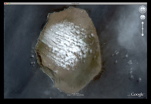
Ile Amsterdam in the southern Indian Ocean, at approximately 37°50’S, 77°34’E. It is home to Base Martin-de-Viviès which is one of the TAAF (Terres australes et antarctiques françaises) bases: http://www.taaf.fr/spip/spip.php?article110
Île Amsterdam
In the middle of the Indian Ocean.
This is Île Amsterdam, part of the French Southern and Antarctic Lands.
How did I find it? From previous contests, I vaguely remembered that there were quite a few isolated islands, like this one, in the South Atlantic & Indian oceans. It was just a matter of browsing through them. 8)
The island is Île Amsterdam, -37.839984° lat, 77.555175° lon.
Île Amsterdam is one of only three islands which are land antipodes of the continental United States.
I’m guessing this is why you chose it. Kudos for picking an incredibly remote and incredibly small location!
I found it by guessing the area. It reminded me of Kauai in Hawaii, so I compared its visual. I then set my eye altitude in Google Earth and started roving around. I got the size WAY wrong… its only 55 km^2! I ended up setting my eye altitude at 2000 km and literally combing for island outlines. It was easy if you set the layers for national borders… the islands show up yellow. When one looks promising, zoom in.
its Ile Amsterdam in the Indian Ocean
Île Amsterdam (new amsterdam island) located in the southern indian ocean.
Very remote!
-Skip
Ile Amsterdam. Finally got bored enough to pop every island group I could think of into google earth and pan around for an hour. Is there a clue I was missing? 😛
It’s AMSTERDAM Island. Sebastian Elcano charted it toward the end of the Magellan expedition… Magellan lost in the Philippines.

Ile Amsterdam in the southern Indian Ocean, at approximately 37°50’S, 77°34’E. It is home to Base Martin-de-Viviès which is one of the TAAF (Terres australes et antarctiques françaises) bases: http://www.taaf.fr/spip/spip.php?article110
Île Amsterdam
In the middle of the Indian Ocean.
This is Île Amsterdam, part of the French Southern and Antarctic Lands.
How did I find it? From previous contests, I vaguely remembered that there were quite a few isolated islands, like this one, in the South Atlantic & Indian oceans. It was just a matter of browsing through them. 8)
The island is Île Amsterdam, -37.839984° lat, 77.555175° lon.
http://en.wikipedia.org/wiki/%C3%8Ele_Amsterdam says:
Île Amsterdam is one of only three islands which are land antipodes of the continental United States.
I’m guessing this is why you chose it. Kudos for picking an incredibly remote and incredibly small location!
I found it by guessing the area. It reminded me of Kauai in Hawaii, so I compared its visual. I then set my eye altitude in Google Earth and started roving around. I got the size WAY wrong… its only 55 km^2! I ended up setting my eye altitude at 2000 km and literally combing for island outlines. It was easy if you set the layers for national borders… the islands show up yellow. When one looks promising, zoom in.
its Ile Amsterdam in the Indian Ocean
Île Amsterdam (new amsterdam island) located in the southern indian ocean.
Very remote!
-Skip
Ile Amsterdam. Finally got bored enough to pop every island group I could think of into google earth and pan around for an hour. Is there a clue I was missing? 😛
It’s AMSTERDAM Island. Sebastian Elcano charted it toward the end of the Magellan expedition… Magellan lost in the Philippines.
Iwo Jima
It’s Ile Amsterdam
It is the Île Amsterdam, http://en.wikipedia.org/wiki/Île_Amsterdam
Located at 37°49?33?S, 77°33?17?E.
-Jeff