Mount Roraima, Venezuela, Brazil and Guyana
5°11’58.76″N 60°44’59.91″W
The very famous Mount Roraima (and Kukenán), Venezuela
5°11’57.67″N
60°47’35.08″W
Monte Roraima at the tripont of Venezuela, Brazil and Guyana
Roraima Tepui: La Fosa (The Pit), Canaima National Park (Venezuela)
5.201444° -60.779194°
Mount Roraima, Venezuela. Also on the border of Guyana and Brazil.
Mount Roraima, near the borders of Guyana, Venezuela and Brazil
5.172865° -60.786633°
Mount Roraima, Venezuela – Brazil – Guyana
Roraima-Tepui, 2810 m, Venezuela-Brazil-Guyana
5°08′36″N 60°45′45″W
the highest muntain of the Pakaraima chain of tepui plateaus in South America
Roraima Tepui, Venezuela. “Lost World”
I have climbed it spending 2 nights on the top. Probably one of the most interesting places I’ve been. Fantastic varieties of orchids.
Mount Roraima
Mount Roraima & Eastern Tepuis, Brazil, 5.203938° -60.777686°
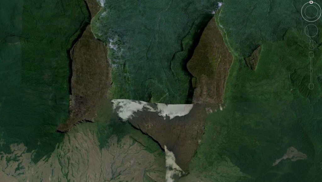
5.215000°,-60.785000° Eastern Venezuela, near the Guyanan border. The clouds cover the Roraima and Cuquenán (or Kukenán) Tepuys (i.e. giant table mountains) of the Pakaraima Plateau belonging to the Guyana shield. These Tepuys chiefly consist of sandstones making up the Roraima Supergroup of Paleoproterozoic age (~1.87 Ga), and were derived mostly from the Trans-Amazon orogenic belt; here they overlie mostly 2.25-2 Ga Trans-Amazonian metamorphic basement units.
Roraima, a mountain (or tepui) on the borders of Venezuela, Guyana and Brazil.
5°11’46.76″N 60°46’43.92″W
Mount Roraima, State of Roraima, Brazil. That was a tough one. I have to admit getting some hints from a pal in the UK. Being in Yankeeland I would not have seen the documentary. Oh well.
charley
Mount Roraima, 5°12′08″N 60°44′07″W / 5.20222°N 60.73528°W

Mount Roraima, Venezuela, Brazil and Guyana
5°11’58.76″N 60°44’59.91″W
The very famous Mount Roraima (and Kukenán), Venezuela
5°11’57.67″N
60°47’35.08″W
Monte Roraima at the tripont of Venezuela, Brazil and Guyana
Roraima Tepui: La Fosa (The Pit), Canaima National Park (Venezuela)
5.201444° -60.779194°
Mount Roraima, Venezuela. Also on the border of Guyana and Brazil.
Mount Roraima, near the borders of Guyana, Venezuela and Brazil
5.172865° -60.786633°
Mount Roraima, Venezuela – Brazil – Guyana
Roraima-Tepui, 2810 m, Venezuela-Brazil-Guyana
5°08′36″N 60°45′45″W
the highest muntain of the Pakaraima chain of tepui plateaus in South America
Roraima Tepui, Venezuela. “Lost World”
I have climbed it spending 2 nights on the top. Probably one of the most interesting places I’ve been. Fantastic varieties of orchids.
Mount Roraima
Mount Roraima & Eastern Tepuis, Brazil, 5.203938° -60.777686°
*** *** *** *** ***
for the ones who love Google Earth/Google Maps puzzles, do not hesitate to join us at
http://earthfunandgames.freeforums.org/google-earth-games-f2.html
*** *** *** *** ***
5.215000°,-60.785000° Eastern Venezuela, near the Guyanan border. The clouds cover the Roraima and Cuquenán (or Kukenán) Tepuys (i.e. giant table mountains) of the Pakaraima Plateau belonging to the Guyana shield. These Tepuys chiefly consist of sandstones making up the Roraima Supergroup of Paleoproterozoic age (~1.87 Ga), and were derived mostly from the Trans-Amazon orogenic belt; here they overlie mostly 2.25-2 Ga Trans-Amazonian metamorphic basement units.
Roraima, a mountain (or tepui) on the borders of Venezuela, Guyana and Brazil.
5°11’46.76″N 60°46’43.92″W
Mount Roraima, State of Roraima, Brazil. That was a tough one. I have to admit getting some hints from a pal in the UK. Being in Yankeeland I would not have seen the documentary. Oh well.
charley
Mount Roraima, 5°12′08″N 60°44′07″W / 5.20222°N 60.73528°W
Mount Roraima.